[ Information on other permanent courses in Alabama & Georgia ]
Oak Mountain Permanent Orienteering Courses
The World Games 2022 Courses
Permanent markers for the 2022 World Games middle distance courses are now in place at Oak Mountain State Park!
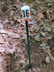
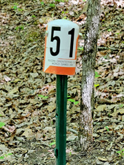
- At each control location is a small green metal fence post topped with a white/orange plastic PVC cap with the control number. These are the same numbers as used on the official 2022 World Games orienteering maps.
- There is a marker at the map issue / time start location, at the start triangle, and at each of the 25 controls locations used for the 2022 World Games orienteering events at Oak Mountain State Park.
- Note that there is no marker at the finish location, since the finish was located in the middle of the beach area behind the park office.
- Also, the green fence posts can be a little hard to find during the warm months, as they blend in with all the green vegetation, but they should be easier to see during the winter months when the leaves are gone.
- Park in the marina parking lot on Terrace Drive.
- Walk 250 meters NE along the road to the bike trail crossing.
- Head SE on the bike trail for about 50 meters, and when the bike trail turns left, there will be a small trail off to the right that runs along the lake, then along the stream to the east.
- Follow the small trail for about 500 meters to the start.
- Note that the map issue / time start, indicated by an upside down "T" on the map, is located 55 meters south of the start triangle. It is located where the yellow hiking trail crosses an intermittent stream.
Beginner Course
The course was designed and placed by Iain and Graeme Wilson in February, 1991. Control #7 was replaced by Scouts from Troop 142 from Decatur in December 2001. The markers are small 4"x6" wooden posts about 18" tall - numbered 1 through 8. The course offers good training for beginners. For a little more challenge, try visiting the controls out of order (example 1,3,4,7,2,5) and with minimum use of trails.
Advanced Course
This is a challenging course and is not intended for the beginner. The course can be finished in 2-3 hours if you walk at a steady pace, don't make many stops to rest, and navigate well. It is designed for easy access from, the North trailhead, the campgrounds and the cabins.
Suggested Route (from north trailhead): 1-2-3-4-7-8-9-6-5-10 (8.2km)
Alternate Route (from north trailhead): 10-1-2-3-4-7-8-9-6-5 (8.0km)
The markers are 4"x4" wooden posts about 2 feet tall, numbered 1-10. There are punches screwed to the back side of all the controls.
The course was placed out on Saturday, March 13, 2004. It was checked on August 4, 2007. The punches on #1 and #6 were replace on Nov 1, 2007 and the punch card updated.
For those who would like to use a USGS map and UTM coordinates:
These coordinates were obtained using a GPS. I had some problems with the Northing coordinates. I had to update the map because it was off by about 220 meters compared to the what I was getting with my GPS unit.
# 2 - 5 27522E 36 91514N - boulder
# 3 - 5 26890E 36 90980N - saddle
# 4 - 5 27411E 36 90700N - saddle
# 5 - 5 27220E 36 90606N - hill
# 6 - 5 26953E 36 90271N - saddle
# 7 - 5 26517E 36 90199N - saddle
# 8 - 5 26217E 36 89590N - saddle
# 9 - 5 27183E 36 89760N - between boulders
#10 - 5 27710E 36 90890N - hill
[ Information on other permanent courses in Alabama & Georgia ]


